
Juneau Alaska Trails
Cool trails in and around Juneau
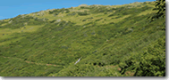
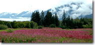
The trails around Juneau offer superb opportunities for hiking, biking and walking. From the rainforest beauty of Mt. Jumbo, to the steep and stunning alpine terrain of Mt. Juneau. The scenery and opportunity to observe wildlife are unparalleled. Great mountains for steep hikes and endless alpine views, hidden coves and lakes for leisurely strolls, to watch wildlife and spectacular scenery.
Exploring the great outdoors and adventure travel activities continue daily despite an occasional showers. Mountains with misty clouds draped about their shoulders are softened and magically beautiful.
Recommended Equipment and Safety Gear for Juneau Alaska Trails
Whether you are going out for a quick day hike or an extended trip, certain items should ALWAYS be packed for safety.
They include:
• Matches/Lighter
• Drinking water and food
• Local maps
• Space Blanket
• Tent/Emergency Shelter
• Extra clothes
• Rain gear
• Knife/Multi-tool
• Flashlight/Headlamp
• First Aid Kit
• Compass and Map/Global Positioning System (GPS)
• Signaling device (e.g. whistle, flares)
Juneau has trails for every level of hiking experience. Some of the more popular and accessible trails include:
Perseverance Trail:
Aside from being one of the most scenic and well-used trails in Juneau, Alaska, the Perseverance Trail is one of the three most historically significant trails in our entire state along with the Chilkoot and Iditarod Trails. The original route, used by natives for goat hunting, fishing and berry picking, was later to become the first road in Alaska after Joe Juneau and Richard Harris found gold in the Silverbow Basin in the 1880’s.
Easy access from downtown. Take Gold St. to Basin Rd. Follow it to the end. Highlights: Old mining ruins, wildflowers, views of Ebner Falls. Caution: Right side of the trail steep and hazardous. Trail uses: Hiking, biking and jogging. 3 miles one-way; roundtrip: 3-4 hours. Elevation: 700 feet. Level: Easy.
Two trails start from points along the Perseverance Trail. The challenging Mount Juneau Trail rises more than 3,500 feet in about 2 miles from a point 1 mile along from the Perseverance trailhead. Go only in dry weather to avoid disastrous falls. The Granite Creek Trail, starting 2 miles in on the Perseverance Trail, climbs 1,200 feet over 1 1/2 miles to an alpine basin. Both are quieter than the Perseverance Trail.
Mount Juneau Trail:
This is a very strenuous hike and very steep in places. I would not try this hike on a rainy day. There are many slick spots and you have to use your hands to climb in some places even on a sunny day. It rises more than 3,500 feet in about 2 miles from a point 1 mile along from the Perseverance trailhead. The trailhead is located to the left about 1 mile from the beginning of Perseverance Trail. Hoary marmots, spruce grouse, and wild flowers and at the top. Many lives have been lost on this mountain because of carelessness. Avalanche danger may persist until late spring, and large snow banks may be present on the steep sections of this trail. (Approx: 7-8 hours round trip; Difficulty: Advanced and strenuous).
Mt. Jumbo Trail:
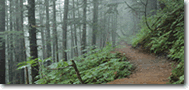
For a beautiful hike in the rainforest and a great waterfall 15 minutes in, try this one. The trail head is located off 5th Street on Douglas Island. It is the highest mountain on the island at 3,500 ft. The trail is well defined and in good shape. From the start is it steep for about 10 minutes then levels out. You’ll get to a clearing after 20 minutes then it steepens sharply. Further in, the forest breaks and then come the tundra rocks. Views of Gastineau Channel, Stephens Passage and Icy Straits from the peak. (Approx. 7-8 hours round trip – Difficulty: First 35 minutes: Easy – After the first 35 minutes: Advanced and strenuous) Not advised on a rainy day.
Granite Creek Trail:
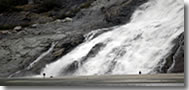
Begins on Perseverance Trail. Granite Creek trailhead located to the left about 2 miles from start of Perseverance Trail. Attractions: wildflowers, alpine lakes, spectacular waterfalls. 3.5 miles one-way; roundtrip about 3-4 hours. Elevation: 1,200 feet. Level: More Difficult.
Mount Roberts Trail:
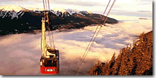
Another hike right from downtown climbs Mount Roberts — just follow the stairway from the top of 6th Street in a neighborhood called Star Hill. The summit is 4 1/2 miles and 3,819 vertical feet away, but you don’t have to go all the way to the top for incredible views and alpine terrain. At the 1,760-foot level, you come to the restaurant at the top of the Mount Roberts tram. Of course, it’s easier to take the tram up and hike down, or start from the tram stop to hike to the summit.
Airport Dike Trail:
Located in Mendenhall Wetlands State Game Refuge. Features: Wheelchair-accessible; close to airport, opportunities for waterfowl and bird watching. Uses: hiking, dog-walking, biking, jogging. Roundtrip of the 1.2-mile one-way hike takes 1-2 hours. Zero elevation gain and excellent maintenance make this trail an easy hike.
Several trails are accessible from the Mendenhall Glacier Visitor Center. The East Glacier and the West Glacier trails are both about 3.5 miles long and rated more difficult. The East Glacier Trail, with an elevation gain of 400 feet takes 2-3 hours roundtrip. The West Glacier Trail, with an elevation gain of 1,300 feet, can be a 5-6 hour roundtrip. Shorter jaunts include the 1.5-mile Nugget Creek Trail, a 1.5-mile Moraine Ecology Trail loop, and a 5-minute, 0.3-mile Photo Point trail that is wheelchair-accessible.
Kaxdigoowu Heen Dei (Mendenhall river trail):
Wheelchair-accessible trail that follows the Mendenhall River greenbelt area, starting at Brotherhood Bridge off Glacier Hwy. The name is Tlingit for “going back clearwater trail.” Expect a lot of traffic, including some bikes and horses on this zero elevation gain hike. Features: access to fishing holes in Montana Creek; vivid wildflowers, including Siberian Irises.
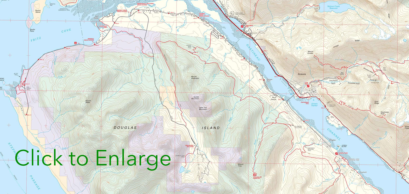
List of Trails and Details:
Amalga (Eagle Glacier) Trail
Length 7.5 miles, elevation gain 500 feet, located at mile 28.4 of Glacier Highway.
Auke Nu (John Muir) Trail
Length 2.5 miles, elevation gain 1552 feet, located at mile 12.3 of Glacier Highway, then .8 miles up Spaulding trail.
Bessie Creek Trail
Length 1.25 miles, elevation gain 900 feet, located at mile 34 of Glacier Highway.
Dan Moller Trail
Length 3 miles, elevation gain 1800 feet, located on Douglas Island; after crossing bridge turn right on Cordova St., then left on Pioneer Ave.
East Glacier Loop Trail
Length 3.5 miles, elevation gain 400 feet, located at the Mendenhall Glacier Visitor Center.
See Mendenhall Glacier
Granite Creek Trail
Length 2 miles, elevation gain 500 feet, located behind town up Basin Rd., then 2.5 miles up Perseverance trail. (see above)
Heintzleman Ridge Route
Length 9.5 miles, elevation gain 3000 to 4000 feet, two trail heads;
one is at at mile 7 of Glacier Highway, just beyond State Highway Building, the other is off Mendenhall Loop Rd., right at Trinity Dr., left at Glacier Valley School, right at Jennifer Dr.; trail head at the end of Jennifer Dr.
Herbert Glacier Trail
Length 4.6 miles, elevation gain 300 feet, located at mile 28 of Glacier Highway.
Montana Creek Trail
Length 9.5 miles, elevation gain 700 feet, located off Mendenhall Loop Rd., onto Montana Creek Rd. to its end.
Moraine Ecology Trail
Length 1.5 miles, elevation gain 10 feet, located at the Mendenhall Glacier Visitor Center.
Mt. Jumbo Route
Length 2.6 miles, elevation gain 3337 feet, located on Douglas Island, 5th street downtown Douglas. (see above)
Mt. Juneau Trail
Length 2 miles, elevation gain 3000 feet, located 1 mile up Perseverance Trail behind town. (see above)
Mt. McGinnis Route
Length 2 miles, elevation gain 1900 feet, located at the end of the 3.4 mile long West Glacier Trail.
Mt. Roberts Trail
Length 2.5 miles to Cross, 3 miles to Gastineau Peak, 4.5 miles to Mt. Roberts Peak, max. elevation gain 3800 feet, located at end of 6th street, downtown. (see above)
Nugget Creek Trail
Length 4 miles, elevation gain 100 feet, located 1.5 miles midway through East Glacier Loop Trail at Mendenhall Glacier Visitor Center.
Perseverance Trail
Length 3 miles, elevation gain 600 feet, located behind town at the end of Basin Rd. (see above)
Peterson Lake Trail
Length 4.3 miles, elevation gain 700 feet, located at mile 24.5 of Glacier Highway.
Point Bishop/Duporzt Trail
Length 1.6 miles Dupont, 8 miles Point Bishop, elevation gain 200 feet, located at the end of Thane Rd.
Point Bridget Trail
Length 3.5 miles, no elevation gain, located at mile 39 of Glacier Highway.
Salmon Creek Trail
Length 3.5 miles, elevation gain 1100 feet, located at mile 2.5 of Egan Dr.(Glacier Hwy.), turn right just after the cement abutment and before the Salmon Creek exit. Boring for first 2/3 of hike, last 1/3 incredibly steep and ends at Salmon lake.
Sheep Creek Trail
Length 3 miles, elevation gain 800 feet to valley, 3500 feet to ridge, located 4 miles South of town off of Thane Rd.
Spaulding Trail
Length 3 miles, elevation gain 1800 feet, located at mile 12.3 of Glacier Highway just past Auke Bay Post Office.
Treadwell Ditch Trail
Length 12 miles, elevation gain 700 feet (down), located .25 miles from the Eagle Crest Ski Area parking lot on North Douglas Island.
West Glacier Trail
Length 3.4 miles, elevation gain 1300 feet, located off Montana Creek Rd., past the campground on the West side of Mendenhall Lake.
Windfall Lake Trail
Length 3.5 miles, elevation gain 100 feet, located at mile 27 of Glacier Highway just before the Herbert River, onto a .2 mile gravel road.
The trail access for Mt. Roberts trail is no longer on 6th St. It has been moved to Basin Rd. The trailhead is on the right side of the road about 200 yards past the foot bridge.
This is a great web page with great information.
My wife and I live in Colorado Springs, CO and are avid mountain hikers. We are possibly moving to Juneau in the near future and are very excited about being able to experience the natural beauty of the area. We are a bit concerned though about the idea of man eating bears. Are they not a problem in the Juneau area?
Thanks for your thoughtful replies.
Don’t hike in the dark in bear country and don’t run early in the morning in the forest all alone and you’ll be just fine. I lived in Southeast Alaska for 10 years and loved every minute of it. Bears aren’t a problem anywhere in Alaska. Bad decisions by people are.
Black bears are around but are usually afraid of people. There is a grizzly here and there. I carry a 10mm just in case.
Isn’t the picture associated with Granite Creek actually Nugget Creek Falls at the Mendenhall Glacier? The waterfalls up Granite Creek are so beautiful, it would be great to have one pictured!
I just moved it farther up the page. Thanks
Can anyone tell me how long the trail by the Jensen Arboretum is, and level of difficulty? Thanks.