
Cordova Alaska
One of Alaska’s most beautiful small towns
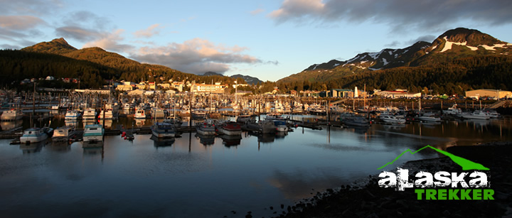
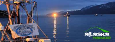
Nestled peacefully at the head of Orca Inlet in Prince William Sound, Cordova Alaska has a mystique all her own. Cordova is a small city near the mouth of the Copper River in Southcentral Alaska. Cordova has glacier-carved mountains, wildlife-rich wetlands, lush forests, and countless waterways. This sleepy little fishing town has activities such as skiing, hiking, wildlife photography, boating, sport fishing, flight seeing, and more.
The Chugach, Wrangell, St. Elias and Alaskan ranges converge in Wrangell-St. Elias National Park, which at 13.2 million acres is the nation’s largest national park. Formed by plate tectonics and shaped by glaciers, some of these mountains rise vertically with an elevation gain greater than that of the Himalayas. Cordova is truly a natural treasure. A rich collection of all the best the great north has to offer.
Here’s a link to our Cordova Trails page.
History of Cordova Alaska
Cordova, Alaska was founded as a result of the discovery of high-grade copper ore at Kennecott, north of Cordova. A group of surveyors from Valdez laid out a town site and Michael James Heney purchased half the land for the terminus of the Copper River and Northwestern Railway after determining that Katalla was a poor harbor. In 1790 the inlet in front of the current Cordova townsite was named Puerto Cordova by Spanish explorer Salvador Fidalgo.
Heney named the new town Cordova after it, although the inlet was later renamed the Orca Inlet. Heney and his crew held a brief ceremony to organize the town on March 26, 1906. A week later crews arrived to begin work on the railroad. The first lots in the new town site, which make up the heart of present-day Cordova, were sold at auction in May 1908. As the railroad grew, so did the town. Eventually schools, businesses, a hospital, and utilities were established. After the railroad was completed Cordova became the transportation hub for the ore coming out of Kennecott. In the years 1911 to 1938, more than 200 million tons of copper ore was transported through Cordova.

The area around Cordova was historically home to the Eyak, with a population of Chugach to the west, and occasional visits from Ahtna and Tlingit people for trade or battle. The last full-blooded Eyak died in 2008, but the native traditions and lifestyle still has an influence on the local culture. Today Cordova is populated with a mix of races, including Aleut Natives, Filipinos, and Caucasian European – North Americans.
Cordova was also once the home of a booming razor clam industry, and between 1916 and the late 1950s it was known as the “Razor Clam Capital of the World.” Commercial harvest in the area was as much as 3.5 million pounds. Returns began declining in the late 1950s, presumably due to overharvesting and a large die-off in 1958. The 1964 Good Friday Earthquake effectively destroyed the industry; in some areas, the ground was thrust up by as much as six feet, exposing the already depleted clam beds. There has been no commercial harvest in the area since 1988 with the exception of a brief harvest in 1993.
In March 1989 the Exxon Valdez oil tanker ran aground on Bligh Reef northwest of Cordova causing one of the most devastating environmental disasters in North America. The Exxon Valdez oil spill severely affected the area’s salmon and herring populations leading to a recession of the local fishing-reliant economy as well as disrupting the general ecology of the area. After many years of litigation, 450 million dollars were awarded for compensatory and punitive damages.
Location:
Cordova Alaska is a small city located near the mount of the Copper River in the Valdez-Cordova Census Area, at the head of Orca Inlet on the east side of Prince William Sound. The population was 2,454 at the 2000 census. Cordova is located within the Chugach National Forest at 60°32’34.1″N 145°45’36.59″W (60.542805, -145.760164). According to the United States Census Bureau, the city has a total area of 75.6 square miles , of which, 61.4 square miles of it is land and 14.3 square miles of it is water. The total area is 18.87% water.
Access:
Despite being on the mainland, Cordova is only accessible via boat or aircraft, as there is no road connecting the town to any other town. It was previously accessible by railroad however the railway is no longer in use largely due to the 1964 Good Friday Earthquake and the resulting destruction it caused to the Million Dollar Bridge. The longest road is the Copper River Highway which follows the old railbed of the Copper River and Northwestern Railway for 49.5 miles. The first 11 miles north of Cordova is paved and the rest is gravel.
In the spring and summer the fast ferry M/V Chenega can get you to Cordova in a 3 hour 15 minute sailing via the the state owned, Alaska Marine Highway System to Valdez and Whittier with whistle stops (the ferry only stops if there are prior reservations) in Tatitlek and Chenega Bay. The M/V Aurora operates in Prince William Sound year round.
Cordova has two airports. Merle K. (Mudhole) Smith Airport is a state-owned airport located 11 miles east of the town center. It has regular jet service provided by Alaska Airlines as well as regular service by Era Aviation. Its main runway is 7500 feet long with an asphalt surface. The Cordova Municipal Airport is 1 mile from the town and is also state owned. It is located on Lake Eyak which also has a seaplane landing area. The sole runway has a length of 1,800 feet with a gravel surface. The municipal airport is mostly used by air taxis and personal aircraft.
Leave A Comment
You must be logged in to post a comment.